Reconnaissance flights survey Tonga

After successfully delivering 88 tonnes of supplies to Tonga, the Australian Defence Force has responded to a request from the Government of Tonga for additional air and sea reconnaissance.
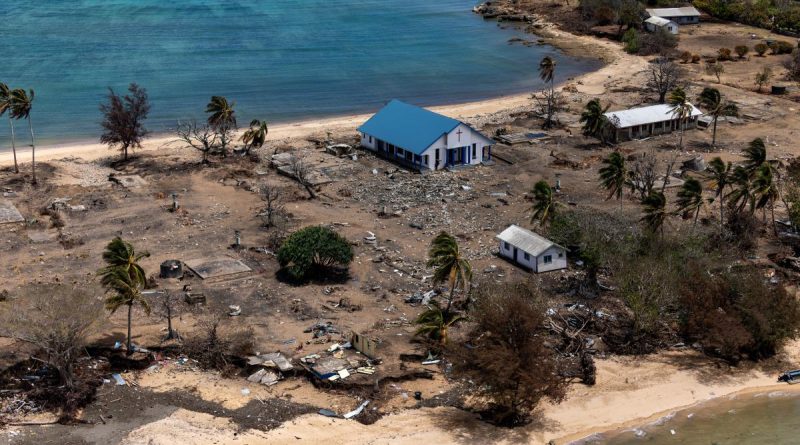
CAPTION: Damage to Atata Island in Tonga, following the eruption of the Hunga Tonga-Hunga Ha’apai underwater volcano and subsequent tsunami. Story by Lieutenant Brendan Trembath. Photo by Petty Officer Christopher Szumlanski.
The ADF aviation capability assigned to Operation Tonga Assist 22 includes three Australian Army CH-47F Chinook helicopters from which operate from the flight deck of the Royal Australian Navy Landing Helicopter Dock HMAS Adelaide.
Officer in command of the Chinook detachment, Major Richard Bremner said the initial flights provided an opportunity for the task group’s reconnaissance elements to gain greater understanding of the islands and the devastation caused.
“We have discovered more people on the islands than expected,” said Major Bremner.
“That’s of interest to both the Government of Tonga and to us, particularly when applying COVID-safe measures to relief operations.
“We may need to determine how we can work with the Government of Tonga to support the movement of those people if we are requested to conduct tasks on those islands.”
To protect Tonga’s COVID-free status, ADF personnel involved in Operation Tonga Assist have had no face-to-face contact with the Tongan community.

CAPTION: Local children on Atata Island in Tonga play on the beach following the eruption of underwater volcano Hunga Tonga-Hunga Ha’apai and subsequent tsunami. Photo by Petty Officer Christopher .
HMAS Adelaide’s embarked helicopters have also been used to observe the extent of airborne volcanic ash which can cause havoc with civil and military aviation by degrading engines and airframes.
“It is nice to see the air is relatively clear,” said Major Bremner.
In addition to aviation lift and airborne reconnaissance, Adelaide is embarked with small water craft including Zodiacs and light landing craft to conduct reconnaissance by sea.
“A Small Boats Platoon from 2nd Battalion, Royal Australian Regiment, will be employed as the primary reconnaissance element to prove safe passage and identify potential landing sites for Army engineers,” said Small Boats Platoon Commander Lieutenant Jordan Chee.
The Platoon has partnered with Navy’s Deployable Geospatial Support Team Two which uses single beam and multi beam echo sounders; and side scan sonars to conduct hydrographic surveys of the area.
It will allow the team to depict a 3D image of the sea floor to assess beach gradients and any obstructions.
.
.

.
.


